


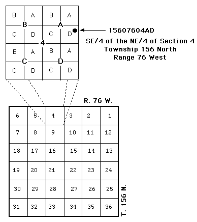
The description used to denote a location is based upon the federal system of rectangular surveys of public land. The first three digits (Cols 1-3) identify the township north of an established baseline, and the second three digits (Cols 4-6) identify the range west of the Fifth Principal Meridian. The numbers located in columns 7 and 8 identify the section within the designated township and range in which the site is located. The letters A, B, C, and D designate, respectively, the northeast, northwest, southwest, and southeast quarter section (160 acre tract), quarter-quarter section (40 acre tract), and quarter-quarter-quarter (10 acre tract). Therefore, a site identified as 15607604AAD would be located in the SE1/4 NE1/4 NE1/4 Section 4, Township 156 North, Range 76 West. Consecutive terminal numbers are added if more than one site is located in a given 10 acre tract, i.e., 15607404ACB1 and 15607604ACB2.